The following is a history of Minnetonka Blvd. “the street,” if you will. For information on the individual buildings, click here. Please contact us with any corrections or additions.
Minnetonka Blvd. is a very old road, dating back to at least 1858, when it separated Minneapolis Township to the north and Richfield Township to the south.
On March 7, 1867, the two northern tiers of Richfield Township were added to Minneapolis Township, so that the entire area that would become St. Louis Park was in Minneapolis Township.
St. Louis Park was incorporated as a Village in 1886.
A map from 1888 clearly shows Minnetonka Blvd. running through the village. Lake Street is not on the map.
In 1890 T.B. Walker and his organization, the Minneapolis Land and Investment Company, bought up 1700 acres of land between Minnetonka Blvd. and Excelsior Blvd. from farmers, an area so large that it took two years to replat the land into 12,000 lots.
In 1891 Walker’s group built a streetcar line along Minnetonka Blvd. from France Ave. to Webster, where it angled southwest along Lake Street. The end of the line was the former Reiss’s Restaurant (then called the “waiting station”). That building still stands, at the confluence of Lake Street, Walker Street, and Highway 7. In the early days, the stretch of Minnetonka Blvd. from France to Lake Street was also called West Lake Street. It was officially changed to Minnetonka Blvd. in February 1918, but carried both West Lake Street and Minnetonka Blvd. street signs for decades to come.
Bicycles became a national craze in the 1890s, and in 1896 Minnetonka Blvd. was a narrow bicycle path. On August 5, 1898 the St. Louis Park Village Council passed an ordinance authorizing the construction of bicycle paths/roads on Lake Street and Minnetonka Blvd. The speed limit was 10 mph, with fines of $10 to $50 or up to 30 days in jail.
In November 1899, “Minnetonka Avenue” was extended to the Right of Way of the Great Northern tracks per J.J. Moldestad (whose land it probably ran through).
Pictures from 1900 of the intersection of Minnetonka Ave. and Falvey Ave. [Louisiana] seem to indicate that when Minnetonka, going west, reached Falvey, it just stopped. This doesn’t sound right, does it?
A perplexing article from 1906 has the headline “Worst Road in Hennepin Co. Right at Entrance of City – the Main Thorofare to Minnetonka Almost Impassable Thru Neglect – Lack of Pull Prevents St. Louis Park From Securing Relief.” Although the article refers to the “Excelsior Road,” the fact that there is a trolley line on the road and that it connects to Lake Street means that this is about Minnetonka Blvd. Here are excerpts from this strongly-worded article:
“The Rocky Road to Dublin” at its worst, was never in more deplorable condition than the stretch of thorofare known as the Excelsior road thru St. Louis park, connecting with West Lake street just beyond the long bridge over the railroad tracks.
This road is not rocky in the true sens of the word, but those who use it go further in naming it. They resort to the inelegant, but expressive “rotten” when they talk of it….
It is one of the most traveled roads in the state, yet on account of the lack of “pull” on the part of the taxpayers of St. Louis Park, the road remains untouched, and those who use it have spilled enough profanity by the wayside to pave it if strong language, in bales, could be used for blocks.
The trolley line to Hopkins takes up one side of the road, leaving a narrow strip for buggies, wagons and carriages…
An active campaign for improvement is to be started in a short time, and if the condition of this stretch is not improved it is likely that some of those responsible for its disgraceful condition will find the lightning striking them from unexpected places. The citizens of the county who use the thorofare have reached their patient’s end and are brewing trouble for the obstructionists. With the addition of sufficient clay to asct as a binder for the sand and gravel, and the proper arrangement for drainage, it could be made a model as well as beautiful stretch of thorofare. The ease with which it could be remedied makes the neglect all the more reprehensible and obvious.
In 1910 four speed signs were ordered for Minnetonka Blvd. at the request of T.H. Colwell.
“Rough Road Vexes Farmers” is the headline of a Minneapolis Tribune article from September 25, 1910. Gardeners, dairymen, and others had to use alternate routes all summer while a new bridge was built to span the canal connective Lake Calhoun and Lake of the Isles. Those in St. Louis Park had to use 28th Street to Dean Boulevard. “To accommodate traffic a temporary road has been constructed, but in such a slip-hod manner that it is difficult to travel. Teamsters fear that in bad weather it will be next to impossible to get over the road.” County Commissioner C.B. Waddell was contemplating a visit to the Minneapolis Park Board to try to get a better road.
In July 1913 Charles M. Loring requested permission to plant elm trees on Minnetonka Blvd. from Minneapolis to Lake Minnetonka.
Also in 1913 Minnetonka Boulevard was described as “a main artery of travel, which is to be made a concrete highway, if present plans are carried out.” And the railroad bridge at Brunswick was built in 1913 as well.
In October 1914, the Village Council passed an ordinance that seemed to indicate that automobiles were only allowed to drive on Excelsior Blvd., Lake Street Blvd. (sic), Minnetonka Blvd., and Superior Blvd. (now 394). The ordinance required autos to have headlights, mufflers, brakes, and a manner of signaling (bell, horn). There were still plenty of horses around: “Every person operating a motor vehicle shall stop upon request or signal from any person in charge of a horse or horses; and shall also stop whenever a horse or horses show signs of fright at the motor vehicle.” This ordinance also ended with a 25 mph speed limit – on the specified roads.
West Lake Street was renamed Minnetonka Blvd. in February 1918, according to Village Council minutes. Businesses would list their addresses variously at West Lake Street/Minnetonka Blvd. for many years.
A school stop sign was authorized for Minnetonka Blvd. at Ottawa in 1933. This was the site of Fern Hill School.
The streetcar from downtown to Reiss’s was discontinued in 1938, and the SLP Spectator reported on September 3, 1938:
Minnetonka Bl., from France Ave. to its junction with Lake St., near Webster Ave, is to be made a fine thoroughfare by the board of County Commissioners, according to P.M. Ellison, St. Louis Park Recorder. Ellison says that he has a conference with Commissioners Heffelfinger, Ferrin and Morse on Tuesday and asked them what the board was going to do about Minnetonka Bl., now that the street car tracks were being removed.
‘They said they were going to make a fine boulevard out of it,’ Ellison declared. ‘They will fill it with gravel, oil, etc., and either this fall or early next spring, will put on a heavy tar material surface so that it will be a fine highway.’
In November 1947 stop and go signals were authorized for the intersections of Ottawa and Minnetonka, and Brookside and Excelsior. Another was recommended for Minnetonka and Louisiana.
In May 1951 the Langford Electric Co. was contracted to erect traffic signals at Minnetonka Blvd. and Ottawa Ave., and Minnetonka Blvd. and Lake Street.
In October 1952 new “prismo-reflectorized” street signs were installed between France and Utica.
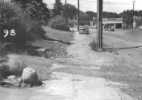
Minnetonka Blvd. was repaved in 1952 and ’53 with much inconvenience to area businesses. The Park Theater lost 3 ½ ft. of frontage as a result. A “road opening” was noted on November 13, 1953. Below is an indication of the conditions before the paving:
The county briefly experimented with concrete paving in the late ’50s, but it broke up quickly and was paved over with asphalt.
The bridge at Minnetonka and Aquila was built in 1960, and rebuilt in 2007.
A 1965 article in the Forum discussed traffic problems on Minnetonka Blvd. Bottlenecks were forming at Texas, Dakota, and Louisiana. At that point, the street was 37 feet wide and carried approximately 9,500 vehicles per day. One could still park on Minnetonka Blvd., and the article, which was written by councilman James R. Helzer, explained new parking restrictions.
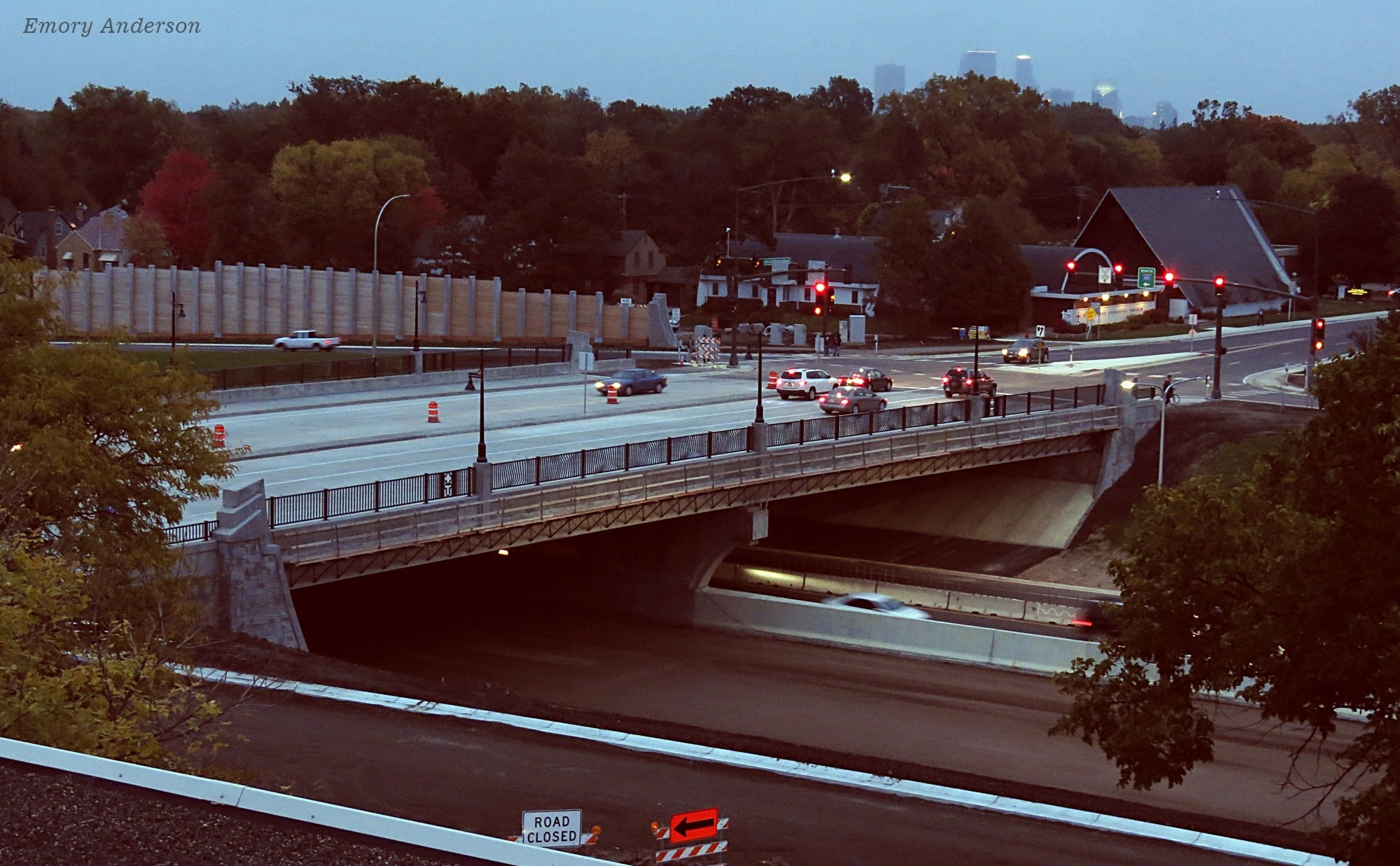
The bridge taking Minnetonka Blvd. over Highway 100, built in 1939, was closed in March 2015 and replaced with a new bridge that opened on October 8, 2015. The replacement of the bridge was necessary for the widening of Highway 100 below, which the series of antiquated bridges at Minnetonka Blvd. and Highway 7 had prevented. See the VIDEO highlighting construction and the reopening ceremony, produced by Scott Smith for Community TV.